South Rockhampton Flood Levee
Consultation has concluded
On 13 October 2020 Council resolved to formally ask the State and Federal Governments to redirect already committed money for the South Rockhampton Flood Levee to other priority projects in the region. While Council remains committed to the project, there has been no movement from State or Federal Government to address the $105 million shortfall in construction costs. If the South Rockhampton Flood Levee is not going to proceed in the immediate future, and given the impacts of COVID-19, Council believes this money could be redirected to other priority projects to support our region and will be formally writing to both State and Federal Governments with this request. Council 100% continues to support the levee and want the other levels of Government to continue to keep it on their infrastructure agenda for our community, and we remain hopeful this project will come to fruition with all levels of Government working together.
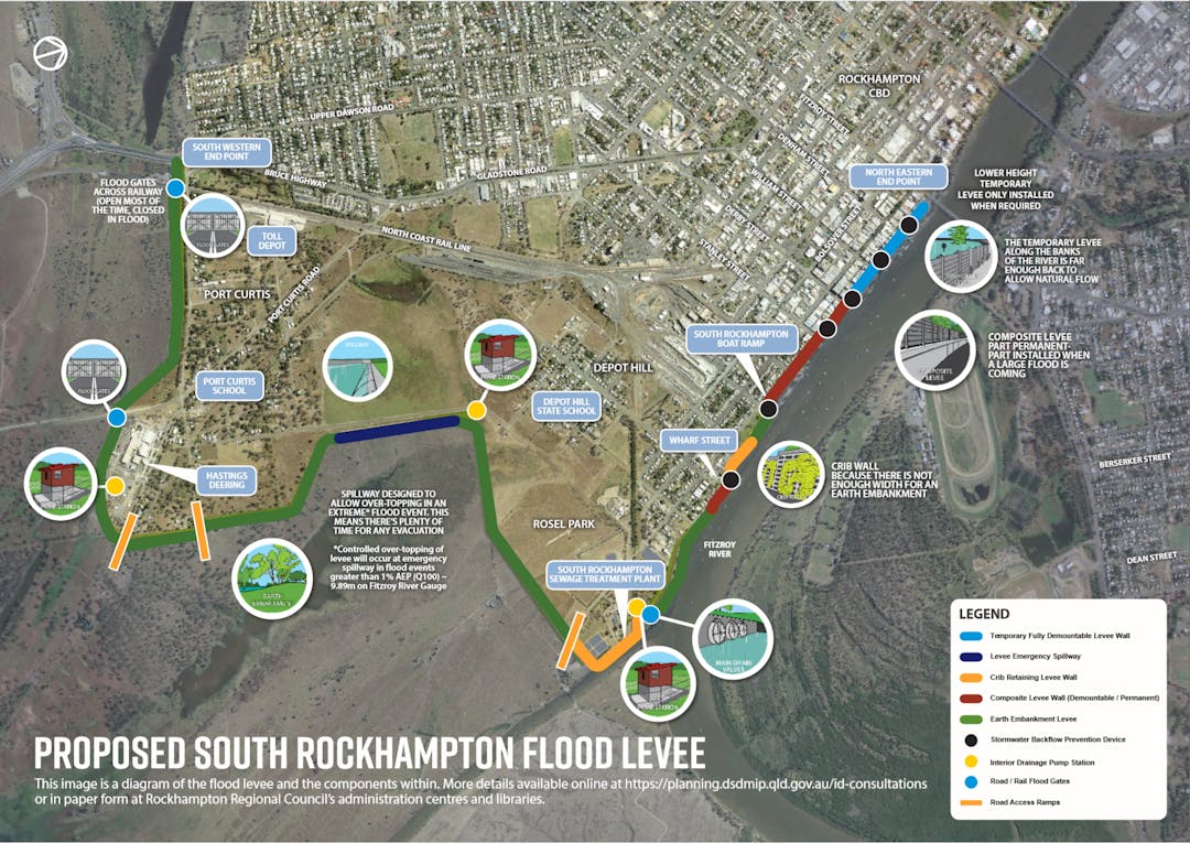
Proposed South Rockhampton Flood Levee
Rockhampton Regional Council is proposing to construct the South Rockhampton Flood Levee at the location described in the map above.
The proposed 8.7-kilometre levee will run from the Rockhampton CBD to the Bruce Highway at Upper Dawson road, and has been identified as the most cost-effective option to mitigate the effects of flooding in Gladstone Road, the lower CBD, Depot Hill, Port Curtis and Allenstown.
The Project Involves:
- 5.9km of up to 4 metres high, varying width, earth embankment;
- 729 metres of crib wall;
- 967 metres of composite flood wall;
- 732 metres of temporary demountable levee;
- 420 metre spillway section at Fiddes Street;
- Two main flood gates at North Coast Rail Line and Old Bruce Highway; and four smaller access flood gates along the river front;
- Access ramps to Jellicoe Street, Port Curties Road and Quay Street; and
- Three pump stations - located at Hastings Deering. Fiddes Street and Main Drain, including detention systems and pumps.
This proposal has been made as a Ministerial Infrastructure Designation under the Planning Act 2016.
The Infrastructure Designation Request (MID-0119-0321) has been made by Rockhampton Regional Council to the Planning Minister under Chapter 2, Part 5 of the Planning Act 2016. The proposal can be found at website: https://planning.dsdmip.qld.gov.au/id-consultations or viewed in hard copy at the following Council administration centres and libraries:
- City Hall, 232 Bolsover Street, Rockhampton City;
- Gracemere Library & Customer Service Centre, 1 Ranger Street, Gracemere;
- Mount Morgan Customer Service Office, 32 Halls Street, Mount Morgan;
- Mount Morgan Library, 31 Morgan Street, Mount Morgan;
- Southside Library, 230 Bolsover Street, South Rockhampton; and
- North Rockhampton Library, 154 Berserker Street, North Rockhampton.
You can make a submission, on or before Friday 21st June 2019 to the Infrastructure Designation team via:
- Online: http://planning.dsdmip.qld.gov.au/id-consultations;
- Email: infrastructuredesignation@dsdmip.qld.gov.au; or
- Post: PO Box 15009, City East QLD 4002.
If you have any questions in relation to this matter please do not hesitate to contact the Infrastructure Designation team on 1300 967 433 or at the above email address.
